Somewhere in the hills of Reasi district sits a dam that quietly shaped decades of India-Pakistan water diplomacy. Salal Dam wasn’t just India’s first hydropower project in Jammu and Kashmir under the Indus Waters Treaty — it’s a genuine case study in how international agreements can constrain engineering decisions, sometimes with consequences that surface years later. If you’re travelling through Reasi or simply want to understand this dam’s real significance, here’s everything worth knowing.
Salal Dam, Reasi Quick Overview
| Detail | Information |
| Also Known As | Salal Hydroelectric Power Station |
| River | Chenab River |
| Location | Near Salal village, Reasi district, Jammu and Kashmir |
| Distance from Reasi | Around 23 km |
| Distance from Jammu Airport | About 75 km |
| Distance from Katra Railway Station | Around 35 km |
| Project Conceived | 1920 |
| Feasibility Studies Began | 1961 |
| Construction Started | 1970 |
| Stage-I Commissioned | 1987 |
| Stage-II Commissioned | 1993–1995 |
| Owned By | NHPC (National Hydroelectric Power Corporation) |
| Dam Type | Run-of-the-river, concrete gravity dam |
| Dam Height | 130 metres |
| Elevation | 1,627 feet above mean sea level |
| Power Generation | 690 MW (two stages of 345 MW each) |
| Beneficiary States | J&K, Punjab, Haryana, Delhi, Himachal Pradesh, Rajasthan, UP, Chandigarh |
| J&K’s Power Share | 12.5% |
Where Salal Dam Is Located
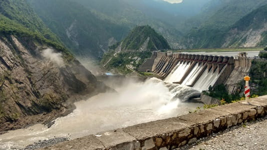
Salal Dam sits near Salal village in Reasi district, roughly 23 kilometres from the district headquarters, in a setting surrounded by mountains that makes for a genuinely scenic approach. It’s positioned just south of Matlot, at the point where the Chenab River bends toward a southerly course.
Getting here typically means routing through Jammu, with the airport around 75 kilometres away, or via Katra railway station, roughly 35 kilometres from the dam, a station many travellers already pass through en route to Vaishno Devi. This proximity to a major pilgrimage route makes Salal Dam a genuinely convenient add-on for visitors already in the region.
The River Behind This Historic Project
The dam is built across the Chenab River, known as Chandrabhaga in Sanskrit texts, one of the major rivers flowing through Jammu and Kashmir before continuing into Pakistan. Downstream, roughly 72 kilometres from Salal, sits Pakistan’s Marala Headworks, from where the Marala-Ravi Link Canal and Upper Chenab Canal distribute this same water across Pakistani Punjab.
This downstream connection is precisely why Salal Dam carries such outsized diplomatic weight. Under the Indus Waters Treaty of 1960, the Chenab is classified as one of the “Western Rivers,” allocated for Pakistan’s use, which meant India’s ability to build and operate a dam here came with genuine, negotiated constraints from the very beginning.
A History Shaped by International Treaty Obligations
The idea for a dam at this location was first conceived in 1920, though it took until 1961 for the Jammu and Kashmir government to begin formal feasibility studies. A project design was ready by 1968, and construction finally began in 1970 under the Central Hydroelectric Project Control Board, operating within India’s Ministry of Irrigation and Power.
What makes Salal’s construction genuinely significant is the 1978 bilateral agreement reached with Pakistan, which came with considerable design concessions. India agreed to reduce the dam’s height, eliminate its operating pool, and permanently plug the under-sluices originally intended for sediment management. These weren’t minor adjustments — they were substantial trade-offs made specifically to satisfy Pakistan’s concerns under the treaty framework, and they’ve had lasting engineering consequences that continue affecting the dam’s performance today.
Following this agreement, construction was formally entrusted to NHPC on an agency basis, and Stage-I of the powerhouse was commissioned in 1987, with Stage-II following between 1993 and 1995. After completion, the project was transferred to NHPC on an ownership basis, cementing its role as a central piece of India’s hydropower infrastructure in the region.
The Ongoing Sediment Challenge
This is genuinely one of the most important technical stories tied to Salal Dam, and it’s worth understanding honestly. Himalayan rivers carry an enormous sediment load, given how young and geologically active these mountains are. Because the under-sluices meant for sediment management were permanently sealed as part of the 1978 agreement, silt has steadily accumulated in the reservoir over the decades, reducing the dam’s effective capacity and creating genuine long-term uncertainty about the project’s operational future.
Some assessments describe the dam’s design compromises as having weakened its long-term viability considerably faster than originally anticipated, with the project reportedly operating at a capacity factor of around 57 percent. In May 2025, following renewed government attention to maximising water use at the site, sediment removal efforts were directed at Salal specifically to restore fuller power generation capacity, indicating that this remains an active, ongoing engineering challenge rather than a settled historical footnote.
Understanding the Water-Sharing and Political Context
It’s worth presenting this fairly, since it touches genuinely sensitive territory. Under the Indus Waters Treaty, Jammu and Kashmir receives 12.5 percent of the energy generated at Salal, with the remainder transmitted to the Northern Grid, benefiting Punjab, Haryana, Delhi, Himachal Pradesh, Rajasthan, Uttar Pradesh, and Chandigarh. J&K also purchases additional power from the project at standard market rates.
This arrangement has drawn criticism within Jammu and Kashmir over the years, with some political voices arguing that the state surrendered more rights over the project than it should have during a 1985 coalition government arrangement. More broadly, the Indus Waters Treaty itself has remained a recurring point of tension in India-Pakistan relations, and it’s worth noting that India suspended the treaty in 2025, following the Pahalgam attack in Indian-administered Kashmir. This is an evolving situation with significant implications for how projects like Salal may operate going forward, and it’s genuinely worth checking current developments if you’re researching this topic for anything beyond a general visit.
What There Is to See at Salal Dam
Despite its technical and political complexity, Salal genuinely functions as a modest tourist attraction for visitors passing through Reasi district. The dam’s mountain-framed setting draws curious visitors wanting to see the structure firsthand, and its scale, at 130 metres high, makes for an impressive sight against the surrounding hills.
Given that this is an active, strategically significant power infrastructure site, visitors should expect security protocols similar to other hydroelectric projects in this sensitive border region, and it’s worth checking current visitor access policies with local authorities before planning a dedicated trip here.
Timings and Practical Details
Specific, formally published visiting hours for casual tourists aren’t widely documented for Salal Dam, which is typical for an active NHPC-operated power facility rather than a dedicated tourism site. Given its status as critical infrastructure in a security-sensitive region, it’s advisable to check current access policies with the Reasi district administration or NHPC directly before planning a visit, rather than assuming open, unrestricted entry.
Frequently Asked Questions
Q1. Why did Salal Dam’s design include so many concessions to Pakistan?
The dam sits on the Chenab River, one of the “Western Rivers” allocated to Pakistan under the 1960 Indus Waters Treaty. A 1978 bilateral agreement required India to reduce the dam’s height, remove its operating pool, and permanently seal sediment-management sluices, concessions made to address Pakistan’s concerns within the treaty framework.
Q2. Is Salal Dam still facing sediment-related challenges today?
Yes, genuinely so. Sealing the sediment-management sluices decades ago has led to ongoing silt accumulation, reducing effective capacity over time. As recently as May 2025, sediment removal efforts were specifically directed at the site to help restore fuller generation capacity.
Q3. How much power does Jammu and Kashmir actually receive from this project?
J&K receives 12.5 percent of the energy generated at Salal, with the remainder distributed through the Northern Grid to Punjab, Haryana, Delhi, Himachal Pradesh, Rajasthan, Uttar Pradesh, and Chandigarh. J&K also purchases additional power from the project at standard rates.
Q4. Can tourists visit Salal Dam freely?
Given its status as an active, strategically significant power project in a security-sensitive border region, it’s advisable to check current access policies with local authorities or NHPC before planning a visit, rather than assuming unrestricted entry is available.