If you’ve ever driven the Valparai-Athirapally route and been stopped at a random-looking checkpoint asking for ₹50, you’ve already brushed past Sholayar Dam without fully realising its scale. This isn’t one dam but a whole complex spanning two states, feeding one of Kerala’s most famous waterfalls, and quietly holding the title of Asia’s second-deepest dam. If you’re planning a Valparai trip, here’s everything worth knowing before you go.
Sholayar Dam Quick Overview
| Detail | Information |
| Also Known As | Solaiyar Dam / Upper Sholayar Dam |
| River | Sholayar River, a tributary of the Chalakudy River |
| Location | Anaimalai Hills, Coimbatore district, Tamil Nadu (border with Kerala) |
| Distance from Valparai | Around 20–23 km |
| Distance from Pollachi | About 64 km |
| Distance from Chalakudy, Kerala | Around 55–104 km (sources vary) |
| Nearest Railway Station | Pollachi |
| Nearest Airport | Cochin International Airport, around 110 km |
| Constructed | 1961–1971 (upper); flanking dam 1964, saddle dam 1965 |
| Dam Type | Concrete masonry gravity dam |
| Dam Height | Around 66–105 metres (sources vary) |
| Dam Length | 430.6 metres |
| Status | Tallest dam in Tamil Nadu; second-deepest in Asia |
| Reservoir Capacity | Around 152.7 million cubic metres |
| Part of | Parambikulam Aliyar Project (PAP) |
| Access | Special permission required for Upper Dam (Tamil Nadu side) |
| Best Time to Visit | December to February |
Where Sholayar Dam Is Located
Sholayar Dam sits in the Anaimalai Hills, roughly 20 to 23 kilometres from Valparai, positioned along the scenic Valparai-Athirapally road that connects Tamil Nadu’s hill station to Kerala’s famous waterfall. This is genuinely one of South India’s most picturesque drives, winding through tea estates, shola forests, and clouds that seem to roll right across the road.
Here’s where it gets a little complicated, and worth understanding before you plan your trip: Sholayar actually refers to two connected dam systems. The Upper Sholayar (Solaiyar) Dam sits on the Tamil Nadu side, closer to Valparai, and falls under the Parambikulam Aliyar Project. The Lower Sholayar Dam sits across the border in Kerala’s Thrissur district, near Malakkappara, and is managed by the Kerala State Electricity Board. Tourists can generally reach the Lower Dam and view areas near the Upper Dam from the road, but actually entering the Upper Sholayar Dam premises requires special permission given its hydroelectric project status.
The River Behind This Cross-State Water System
The dam is built across the Sholayar River, a tributary that eventually joins the larger Chalakudy River system, one of Kerala’s significant westward-flowing rivers. The Sholayar sub-basin itself covers around 403 square kilometres of hilly Western Ghats terrain, an area that receives extraordinarily heavy monsoon rainfall, often exceeding 500mm in July and August alone.
This intense rainfall is exactly why the region generates such a substantial water yield, but it also means the river system demands careful, coordinated management between two states, since water flowing through Sholayar directly affects both Tamil Nadu’s irrigation needs and Kerala’s power generation and downstream ecosystems, including the flow reaching Athirapally Falls.
A History Rooted in Interstate Cooperation
The story here genuinely involves two separate but connected construction efforts. On the Tamil Nadu side, the Upper Sholayar Dam was built between 1961 and 1971 as part of the broader Parambikulam Aliyar Project, a multi-purpose initiative that Tamil Nadu executed in cooperation with Kerala from 1958 to 1990. This project diverts surplus water from eight west-flowing rivers in the Anaimalai Hills, ultimately irrigating over 174,000 hectares across both states.
On the Kerala side, planning for the Lower Sholayar Dam began with a 1951 preliminary report by engineer V. Ranganathan, examining the economic viability of diverting Sholayar waters for power generation. The newly formed Kerala State Electricity Board took this forward starting in 1958, positioning Sholayar as Kerala’s second hydroelectric scheme after the Poringalkuthu project. Construction proceeded through the early 1960s, with the main dam, flanking dam, and saddle dam all commissioned in 1965.
Given the shared river system straddling two states, a formal water-sharing agreement was signed on 29 May 1970 between the Kerala and Tamil Nadu governments, applied retrospectively from November 1958. This agreement stipulated how much water Tamil Nadu would release to Kerala’s Sholayar reservoir while still allowing diversions for its own PAP system, a genuinely important piece of interstate water diplomacy that’s kept this shared resource functioning for over six decades.
An Ongoing Water-Sharing Reality
It’s worth being honest that this cooperation hasn’t always been entirely smooth. As recently as 2025, disputes have persisted regarding water releases under the Parambikulam Aliyar Project, with reports of Tamil Nadu proceeding with certain project activities despite Kerala’s objections. Given the basin’s steep terrain and intense monsoon rainfall, these tensions matter beyond just administrative disagreement — they directly affect flood risk management during heavy rain events, with historical episodes like the devastating 2018 Kerala floods highlighting just how quickly water levels can overwhelm multiple dams across this basin when coordination breaks down.
What Makes This Dam Complex Genuinely Impressive
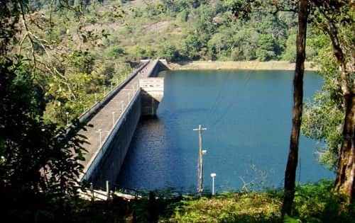
The scale here is worth appreciating properly. The Upper Sholayar Dam stands as the tallest dam in Tamil Nadu according to some measurements, while the broader Sholayar complex is often cited as Asia’s second-deepest dam. The Lower Sholayar Dam complex on the Kerala side comprises three separate structures — the main masonry-gravity dam, a flanking dam with an ogee spillway featuring five radial gates, and a composite saddle dam, together impounding a reservoir with a gross storage capacity of roughly 153 million cubic metres.
The Sholayar Power Station on the Kerala side has an installed capacity of 480 MW, making it one of the state’s larger hydroelectric facilities, contributing meaningfully to reducing Kerala’s dependence on thermal power.
What There Is to See and Do
Most visitors experience Sholayar through the drive itself rather than direct dam access, and honestly, that’s often enough. The road offers stunning viewpoints over the reservoir, framed by the Anaimalai Hills’ dense forest cover, with photo opportunities at multiple pull-offs along the route, particularly near the small bridge leading toward Athirapally.
A checkpost along the route typically charges a nominal entry fee, often cited around ₹50, and beyond that, don’t expect elaborate tourist infrastructure — this is a working hydroelectric zone rather than a developed picnic destination. Small shops near the checkpost serve basic snacks, with fresh fish and bread omelette specifically mentioned by regular visitors as worth trying. A short waterfall along the Sholayar-Athirapally stretch offers a quick, kid-friendly dip, and the Balaji Temple nearby, though reached via a genuinely narrow path, rewards those willing to navigate it carefully.
An Honest Note on Water Levels
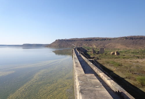
Several recent visitor accounts specifically mention the reservoir appearing completely dry or at very low levels during certain visits, even following heavy monsoon seasons. This isn’t unusual for a working hydroelectric reservoir subject to active water management and release schedules, but it does mean the visual spectacle you’re hoping for isn’t guaranteed regardless of season. It’s worth checking recent visitor reports or current water levels before making a special trip purely for scenic reservoir views.
Timings and Entry Details
Visiting hours reported across sources vary somewhat, with some citing 8:00 AM to 5:00 PM and others listing 9:00 AM to 6:00 PM, generally Monday through Saturday. Entry to roadside viewpoints is typically free, though the checkpost fee for proceeding further along certain stretches runs around ₹50. Given the Upper Sholayar Dam’s status as an active hydroelectric project, direct access requires special permission, so casual visitors should expect to enjoy the area primarily through roadside views and the Lower Dam’s more accessible surroundings.
Best Time to Plan Your Visit
December through February offers the most comfortable weather for the drive and any outdoor time around the dam area, avoiding both Tamil Nadu’s warmer months and the heaviest monsoon rains. That said, some sources specifically recommend June through September for those hoping to see the reservoir at its fullest, since this aligns with peak monsoon inflow, though as noted above, actual water levels can vary considerably depending on current release schedules regardless of season.
Frequently Asked Questions
Q1. Why are there two different Sholayar Dams, and which one can I actually visit?
The Upper Sholayar Dam sits in Tamil Nadu and requires special permission as an active hydroelectric project, while the Lower Sholayar Dam sits across the border in Kerala’s Thrissur district. Most tourists experience the area through roadside viewpoints and the more accessible Lower Dam surroundings rather than entering the Upper Dam directly.
Q2. Why does the reservoir sometimes appear completely dry despite heavy monsoons?
This reflects active water management and release schedules tied to the dam’s hydroelectric and irrigation functions rather than a lack of rainfall. Several recent visitors have specifically noted very low or empty reservoir levels even after strong monsoon seasons, so it’s worth checking current conditions before planning a trip around scenic water views.
Q3. Is there an entry fee to visit the Sholayar Dam area?
A checkpost along the route typically charges a nominal fee, often around ₹50, for proceeding further along certain stretches, though roadside viewpoints generally remain freely accessible.
Q4. Can I combine a Sholayar Dam visit with Athirapally Falls in one trip?
Yes, easily, and it’s genuinely one of the most popular ways to experience this route. The Valparai-Athirapally road passes directly by Sholayar’s viewpoints, making it simple to combine both destinations into a single scenic day trip.