If you’ve ever wondered why Punjab and Jammu & Kashmir keep disputing water and power rights over a single dam, Ranjit Sagar is exactly where that story plays out. Named after the legendary Maharaja Ranjit Singh, this is Punjab’s largest hydroelectric project and one of the highest earth-fill dams anywhere in India. It’s also become a genuinely popular picnic and boating destination near Pathankot, though visiting here requires a bit more planning than your average dam trip. Here’s everything worth knowing.
Ranjit Sagar Dam, Pathankot Quick Overview
| Detail | Information |
| Also Known As | Thein Dam |
| River | Ravi River |
| Location | Shahpur Kandi, near Pathankot, Punjab (border with Jammu & Kashmir) |
| Distance from Pathankot | Around 30 km |
| Distance from Kathua (J&K) | Around 30 km |
| Nearest Airport | Pathankot Airport |
| Nearest Railway Station | Pathankot Railway Station |
| Feasibility Studies Began | 1953 |
| Construction Started | 1981 |
| Generators Commissioned | 2000 |
| Project Completed | March 2001 |
| Dam Type | Earth-fill embankment dam |
| Dam Height | Around 160 metres above riverbed |
| Dam Length | 617 metres |
| Reservoir Capacity | Around 32 billion cubic metres |
| Reservoir Split | 60% in Jammu & Kashmir, 40% in Punjab |
| Power Generation | 600 MW (four 150 MW turbines) |
| Entry Requirement | Special permission pass required |
| Best Time to Visit | October to April |
Where Ranjit Sagar Dam Is Located
Ranjit Sagar Dam sits at Shahpur Kandi township, roughly 30 kilometres from Pathankot in Punjab, and almost exactly the same distance from Kathua on the Jammu & Kashmir side. This near-equidistant positioning genuinely reflects the dam’s unique administrative situation, straddling a sensitive interstate and inter-territorial boundary rather than sitting cleanly within a single state.
Pathankot serves as the main gateway for most visitors, with its railway station and airport both offering convenient connections before the final 30-kilometre drive to the dam itself. The route is consistently described as scenic, winding through Punjab’s countryside before the terrain becomes noticeably hillier as you approach the dam site.
The River Behind This Massive Reservoir
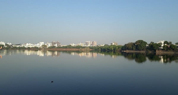
The dam is built across the Ravi River, one of the five rivers that historically gave Punjab its name, positioned about 24 kilometres upstream of the Madhopur Barrage. The Ravi’s waters, once regulated here, continue downstream to serve irrigation needs across both Punjab and parts of Jammu & Kashmir, making this dam a critical control point for a river that both regions genuinely depend on.
What makes this reservoir’s geography particularly notable is the sheer imbalance in territorial distribution — roughly 60 percent of the massive water body actually lies within Jammu & Kashmir, while only 40 percent falls within Punjab, despite the dam infrastructure itself being built and operated by the Punjab government. This split is at the very heart of the tensions that have followed this project for decades.
A History Spanning Nearly Seven Decades
The idea for a dam on the Ravi near Thein village actually dates back to 1912, when the earliest proposal for a 200-foot structure was first mooted. A committee led by Mr. Willey inspected the site in 1926-27 and recommended further survey work, but genuine progress stalled for decades, with only geological inspections continuing until 1954.
It wasn’t until 1957 that the storage dam proposal actually materialised into a formal irrigation scheme, with power generation deliberately postponed for a later phase. The first multipurpose project report reached the Government of India in 1964, though final approval didn’t come until April 1982. Feasibility studies stretched from 1953 all the way through geotechnical surveys completed in 1980, and actual construction finally began in 1981. The generators were commissioned in 2000, with the full project declared complete in March 2001, nearly 90 years after the very first proposal was made.
Understanding the Punjab-J&K Dispute
This is genuinely important context, and it deserves fair treatment from both perspectives. Given how much of the reservoir sits within Jammu & Kashmir’s territory, disputes have persisted for years over water usage, electricity sharing, employment opportunities, compensation for displaced locals, and land acquisition.
On 12 May 2017, the Jammu & Kashmir government formally raised these concerns at the Northern Zonal Council Meeting in Chandigarh. Following this, India’s Ministry of Home Affairs mandated the construction of additional barrages designed to give both regions more equitable rights over the dam’s benefits, specifically to help Jammu & Kashmir irrigate its Samba and Kathua districts. While Punjab’s government agreed in principle to share electricity generated through the project, several of Jammu & Kashmir’s earlier claims, including a reported ₹8,000 crore demand for losses in 2017, remained unresolved for a considerable time, reflecting how genuinely complicated interstate water-sharing arrangements can become in India, even decades after a project’s completion.
What Makes This Dam Engineering-Worthy
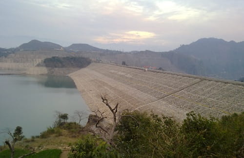
Beyond the political complexity, Ranjit Sagar genuinely holds its own on technical merit. It’s recognised as one of the highest earth-fill dams in India, and its penstock pipes, the massive tubes carrying water to the turbines, are reportedly the largest in diameter anywhere in the country. The power station’s four 150 MW turbines give it a combined capacity of 600 MW, making it Punjab’s largest hydroelectric project by a considerable margin. In 2019-20, the plant reportedly achieved a record generation of 2,099.189 million units, a genuine operational milestone since the project’s commissioning.
What There Is to See and Do
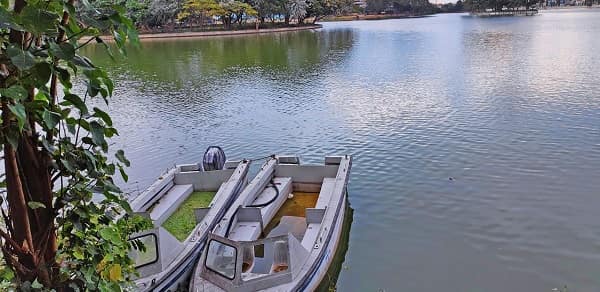
The reservoir, known locally as Ranjit Sagar Lake, offers boating as its central recreational draw, with visitors describing genuinely memorable rides across the water, especially when the reservoir sits at a fuller level. Fishing is popular here too, and the surrounding forested hills support a good variety of birdlife, making this a worthwhile stop for casual birdwatchers and nature photographers alike.
A newly constructed wire bridge near the dam, reportedly only the second of its kind in India, has become something of a novelty attraction worth seeking out if you’re visiting. Picnic spots dot the area, and tourist cottages near the dam offer overnight stays for those wanting to extend their visit beyond a day trip, with booking and payment for these cottages handled directly at the entrance.
An Important Access Note
This is genuinely essential to know before you plan a visit. Unlike most tourist-friendly dams, entering Ranjit Sagar Dam requires a special permission pass from the relevant authorities, given the site’s strategic and security-sensitive nature near an interstate and near-border location. Several visitor accounts specifically mention being turned back at the gate after travelling all the way there without prior clearance, so it’s worth confirming current permission requirements and application processes well before you set out, rather than assuming walk-in access will be available.
Timings and Best Time to Visit
October through April is widely recommended as the best window, offering pleasant weather suited to both sightseeing and any water-based activities you’re hoping to enjoy. Given that the dam remains accessible year-round in principle, but certain activities like water sports depend heavily on current water levels and seasonal conditions, it’s sensible to check current status alongside confirming your entry permission before finalising travel plans.
Frequently Asked Questions
Q1. Do I need special permission to visit Ranjit Sagar Dam?
Yes, genuinely so. Visitors need a permission pass from the relevant authorities to enter the dam area, and several travellers have been turned away at the gate without this clearance. It’s essential to confirm current requirements and arrange permission before travelling to the site.
Q2. Why is there an ongoing dispute between Punjab and Jammu & Kashmir over this dam?
Since roughly 60 percent of the reservoir lies within Jammu & Kashmir despite the dam being built and operated by Punjab, disagreements have persisted over water usage, electricity sharing, compensation, and land acquisition, with formal discussions and claims raised as recently as 2017.
Q3. Is boating available year-round at Ranjit Sagar Dam?
Boating and other water sports generally depend on current water levels and seasonal conditions, so while the site remains accessible throughout the year, it’s worth checking current activity availability before planning your visit specifically around boating.
Q4. What’s the wire bridge near Ranjit Sagar Dam, and is it worth visiting?
It’s a relatively new suspension-style wire bridge near the dam, reportedly only the second of its kind in India, and it’s genuinely worth seeking out as a novelty stop if you’re already visiting the dam and have secured the necessary entry permission.