If you’ve ever wondered what India’s very first planned eco-tourism destination actually looks like, Thenmala is the answer. This isn’t just Kerala’s largest irrigation project quietly regulating water for three districts — it’s a genuinely pioneering model that the World Tourism Organisation has specifically recognised for balancing conservation with recreation. If you’re planning a trip through Kollam district, here’s everything worth knowing before you go.
Thenmala Dam Quick Overview
| Detail | Information |
| Also Known As | Parappar Dam, Kallada Dam |
| River | Kallada River, at the confluence of Kulathupuzha, Parappar, and Shendurney rivers |
| Location | Thenmala village, Kollam district, Kerala |
| Distance from Kollam | Around 40–68 km |
| Distance from Thiruvananthapuram | Around 70–75 km |
| Nearest Railway Station | Thenmala (2 km) or Shengottai, Tamil Nadu (32 km) |
| Nearest Airport | Trivandrum International Airport, around 73–75 km |
| Project Started | 1961 |
| Foundation Stone Laid | 26 January 1972, by T.K. Divakaran |
| Commissioned | 26 May 1986, by K. Karunakaran |
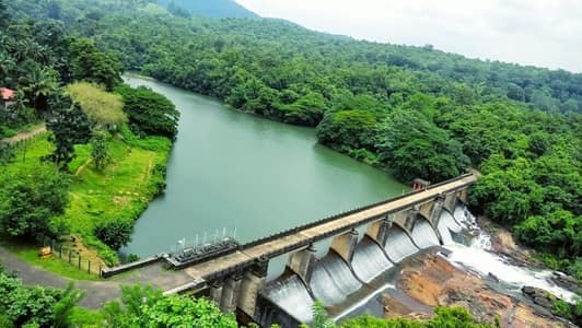
| Dam Type | Composite earthen and masonry gravity dam |
| Dam Length | 335 metres |
| Dam Height | 85.35 metres from deepest foundation |
| Status | Kerala’s largest irrigation project; India’s first planned eco-tourism destination |
| Reservoir Capacity | 524 million cubic metres |
| Irrigation Coverage | Around 37,600–53,514 hectares across Kollam, Pathanamthitta, Alappuzha |
| Best Time to Visit | October to March, evenings especially |
Where Thenmala Dam Is Located
Thenmala Dam sits in Thenmala village, Kollam district, right at the foothills of the Western Ghats, close to the Kollam-Tenkasi road. Distances vary depending on your exact route, ranging from roughly 40 to 68 kilometres from Kollam city and about 70 to 75 kilometres from Thiruvananthapuram.
Thenmala railway station, sitting on the scenic Sengottai line, is genuinely just 2 kilometres from the dam, making this one of the more conveniently rail-accessible dams in Kerala. Trivandrum International Airport remains the nearest air link, with taxis and rental cars readily available for the onward journey.
The River Behind This Massive Reservoir
The dam is built across the Kallada River, precisely at the confluence of three major tributaries: the Kulathupuzha river, which arises from streams originating in the Ponmudi hills; the Parappar river, flowing down from the windward side of the Agasthyamala Biosphere Reserve; and the Shendurney river, originating near the Aryankavu-Sengottai Pass. This unusual three-river meeting point is exactly why the resulting reservoir stretches so impressively, forming what’s often described as Kerala’s longest and largest reservoir.
The catchment area feeding this system spans roughly 549 square kilometres, drawing from some of the Western Ghats’ most biodiverse forest terrain, which is exactly why the surrounding region carries such significant ecological weight beyond the dam’s engineering function.
A History Rooted in Kerala’s Largest Irrigation Ambition
Planning for what became the Kallada Irrigation and Tree Crop Development Project began in the late 1950s, part of Kerala’s broader post-independence push toward agricultural self-reliance. The project formally started in 1961, though it took over a decade for construction to actually begin — the foundation stone was laid on 26 January 1972 by T.K. Divakaran, and the dam was finally completed and commissioned on 26 May 1986 by then Chief Minister K. Karunakaran, alongside the broader Kallada Irrigation Project.
This makes Thenmala Dam a genuinely long-gestating project, spanning roughly 25 years from initial planning to commissioning. Once operational, its gravity-fed canal system, comprising left and right bank main canals stretching well over 50 kilometres each, began supplying water across a culturable command area of approximately 53,514 hectares in Kollam, Pathanamthitta, and Alappuzha districts, targeting paddy fields alongside tree crops like rubber and coconut.
From Irrigation Project to India’s First Planned Eco-Tourism Model
This is genuinely the most remarkable part of Thenmala’s story. Rather than simply functioning as irrigation infrastructure, the area surrounding the dam was deliberately developed into India’s first planned eco-tourism destination, structured across distinct zones: a Culture Zone, a Leisure Zone, and an Adventure Zone. The project earned recognition from the World Tourism Organisation as one of the best eco-friendly tourism projects in the world, a genuinely significant endorsement for an Indian tourism initiative.
The name “Thenmala” itself translates to “honey hill,” a reference to the area’s peculiar floristic composition, which produces forest honey renowned locally for its medicinal properties. Today, the entire project is managed by the Thenmala Eco-tourism Promotion Society, which has created meaningful local employment while maintaining strict biodiversity protection, given the area’s status as a UNESCO World Heritage buffer zone.
What Makes This Project Genuinely Distinctive
Unlike most Indian dam-tourism sites that developed organically over decades, Thenmala’s eco-tourism infrastructure was deliberately designed from the outset with conservation as a core principle. The reservoir is surrounded by the Shendurney Wildlife Sanctuary on all sides, and boat rides here specifically allow visitors to spot wild animals along the banks, a genuinely rare offering for a dam-based destination.
A musical dancing fountain, a butterfly safari, and a deer rehabilitation centre round out the project’s blend of education and entertainment, while a sway (hanging) bridge and an amphitheatre add further attractions that go well beyond what you’d typically find at a standard irrigation dam.
What There Is to Do at Thenmala Dam
Trekking to the top of the dam is genuinely one of the highlights here, requiring roughly a kilometre’s walk up steep roads and steps, but rewarding visitors with breathtaking panoramic views over the water and surrounding hills. It’s worth carrying your own drinking water for this climb, since several visitor reviews specifically mention broken or poorly maintained water taps on-site.
Boating remains a central activity, with paddle boats, row boats, and canoeing all available on the reservoir, giving you a genuinely different vantage point to spot water birds and take in the scenery. Guided trekking through the surrounding forest trails offers varying difficulty levels, all showcasing the Western Ghats’ mountain ranges, while jungle camping is possible with prior permission from the Kerala Forest Department and a certified local guide.
Nearby, the 13-arched Pathimoonam Kannara Bridge and Palaruvi Falls make for worthwhile add-ons if you’re extending your Thenmala visit into a fuller day trip.
A Practical Note Worth Knowing
It’s worth being aware that maintenance concerns have surfaced periodically at the dam. There have been reports of a minor leak at Thenmala Dam in recent years, though Kerala’s dam safety authorities have described it as not a cause for concern. This is a genuine, documented detail rather than an alarming ongoing issue, but it’s worth checking current status if you’re specifically planning activities that involve close proximity to the dam structure.
Timings and Entry Details
Thenmala Dam and its ecotourism zones are open all days of the week, with ticket rates for individual activities available through the official Thenmala Ecotourism tariff listings. Evenings, particularly between November and February, are widely recommended as the best time to visit, both for cooler temperatures and a more atmospheric experience around the musical fountain and hanging bridge.
Best Time to Plan Your Visit
October through March offers the most comfortable weather for trekking, boating, and general sightseeing, avoiding the intense heat and heavy rainfall that monsoon season brings to this part of the Western Ghats. That said, monsoon does play a genuine ecological role here, reviving and regenerating the region’s forest cover and vegetation, even though it’s not the ideal window for outdoor activities.
Frequently Asked Questions
Q1. What makes Thenmala Dam different from other dam-tourism sites in Kerala?
It was deliberately designed as India’s first planned eco-tourism destination, structured across distinct culture, leisure, and adventure zones, and recognised by the World Tourism Organisation as one of the world’s best eco-friendly tourism projects, rather than developing organically as a tourist spot over time like most other Indian dams.
Q2. Is it safe to trek to the top of Thenmala Dam?
Generally yes, though it involves a roughly one-kilometre climb up steep roads and steps, so carrying your own drinking water is essential since on-site facilities like water taps have been reported as poorly maintained by several visitors.
Q3. Can I spot wildlife during a boat ride on the reservoir?
Yes, genuinely so. Since the reservoir is surrounded by the Shendurney Wildlife Sanctuary, boat rides here offer a real chance to spot wild animals along the banks, alongside a variety of water birds.
Q4. Is jungle camping allowed near Thenmala Dam?
Yes, but it requires prior permission from the Kerala Forest Department and must be conducted with a certified local guide, given the area’s protected status as a UNESCO World Heritage buffer zone.