Somewhere beneath the calm blue waters of Tehri Lake lies an entire town that no longer exists. That’s the kind of story Tehri Dam carries with it — a structure so massive it didn’t just change how India generates power, it literally erased a centuries-old settlement and rebuilt an entirely new town in its place. If you’re travelling through Uttarakhand, or you’re simply curious why this dam keeps showing up in conversations about clean energy, water security for North India, and even earthquake risk debates, this guide breaks it all down clearly.
Here’s what you actually need to know before planning a visit or just understanding the bigger picture.
Quick Overview
| Detail | Information |
| River | Bhagirathi River, with contribution from the Bhilangana River |
| Location | Near New Tehri town, Tehri Garhwal district, Uttarakhand |
| Distance from Rishikesh | Roughly 75–90 km |
| Distance from Dehradun | About 90–100 km (via Jolly Grant Airport route) |
| Nearest Airport | Jolly Grant Airport, Dehradun |
| Nearest Railway Station | Rishikesh |
| Construction Started | 1978 (first proposed in 1961) |
| Completed | 2006 |
| Dam Type | Rock and earth-fill embankment dam |
| Height | 260 metres |
| Ranking | Tallest dam in India, among the tallest in the world |
| Power Generation Capacity | Over 1,000 MW |
| Reservoir Name | Tehri Lake |
| Reservoir Area | Around 52 sq. km |
| Visiting Hours | Generally 9:00 AM to 5:00–6:00 PM daily |
| Entry Fee | No major entry fee for viewpoints; activities charged separately |
| Access to Main Structure | Restricted for security reasons |
Where Tehri Dam Is Located
Tehri Dam sits near New Tehri town in the Tehri Garhwal district of Uttarakhand, built right where the Bhagirathi and Bhilangana rivers meet. It’s roughly 75 to 90 kilometres from Rishikesh, making it a fairly common addition to itineraries for travellers already exploring the Rishikesh-Dehradun-Mussoorie belt.
The drive there is genuinely part of the experience, winding through hill roads that pass valleys, pine forests, and small Garhwal villages. That said, the roads do get narrow and steep in sections, and monsoon travel can be affected by landslides or fog, so it’s worth checking road conditions before setting out, especially between June and September.
The Rivers Behind This Massive Structure
Tehri Dam is built primarily across the Bhagirathi River, one of the two headstreams that eventually form the Ganga. The Bhilangana River also feeds into the reservoir, which is why some sources describe the dam as sitting at the confluence of both. Together, these Himalayan rivers create Tehri Lake, a reservoir large enough to hold around 4 cubic kilometres of water, spread across roughly 52 square kilometres.
This isn’t just a scenic water body. The dam regulates water supply for irrigation and drinking needs across a huge stretch of North India, while simultaneously powering a hydroelectric project that sends electricity to Uttarakhand, Uttar Pradesh, Delhi, Punjab, Haryana, Rajasthan, and beyond.
A History Marked by Both Achievement and Controversy
The idea of damming the Bhagirathi at this location goes back to 1961, but it took until 1978 for actual construction to begin. What followed was nearly three decades of delays, driven by technical challenges, environmental concerns, and a well-documented anti-Tehri Dam movement that raised serious questions about displacement and ecological impact in the region.
The project was finally completed in 2006, and its scale is genuinely staggering — at 260 metres, it stands as the tallest dam in India and ranks among the tallest of its kind anywhere in the world.
The most significant human cost of this project was the submergence of Old Tehri, a historic town that had existed for centuries. As the reservoir filled, the entire town disappeared underwater, and its residents were relocated to a newly built town called New Tehri, situated on higher ground nearby. It’s a story that still comes up in local conversations, and travellers visiting the region will often hear firsthand accounts from residents about what was lost.
There’s also an ongoing seismic concern worth mentioning honestly. Tehri Dam sits within the Himalayan seismic zone, an area considered vulnerable to significant earthquakes, and this has remained a point of scientific and public debate since the dam’s construction, even though the structure was engineered to withstand substantial seismic activity.
What You Can Actually Do at Tehri Lake
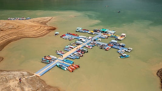
While access to the dam’s core structure is restricted for security reasons, the surrounding Tehri Lake area has developed into a genuine adventure tourism hub. Boating remains the most popular activity, letting visitors take in the sheer scale of the reservoir against the backdrop of steep Himalayan slopes.
For those chasing more adrenaline, jet skiing, water zorbing, kayaking, and even paragliding have become increasingly available around the lake in recent years. The Banana Boat Ride, sometimes called the Hotdog Ride, is a particular favourite among younger visitors, where an inflatable boat gets pulled in a zigzag pattern until riders inevitably end up in the water. There’s also growing interest in houseboats and floating stays on the lake, with the Uttarakhand government reportedly exploring further development of the area into a more structured adventure park.
Timings, Entry, and Security Rules You Should Know
Most current sources place general visiting hours between 9:00 AM and 5:00 or 6:00 PM daily. There’s typically no major entry fee just to access designated viewpoints around the dam and lake, though individual water sports and adventure activities are charged separately by their respective operators.
Here’s the part worth taking seriously — Tehri Dam is classified as a high-security installation. Visitors are generally not permitted to walk onto or closely approach the main dam structure itself. Photography near the dam and security zones may be restricted, and drone usage is strictly prohibited without prior official clearance. Most tourism activity happens instead around designated viewpoints and the lake’s tourism zones, which still offer genuinely impressive views without compromising security protocols.
Best Time to Visit
The most commonly recommended window is between October and April, when the weather stays pleasant for both sightseeing and outdoor activities. Some sources also point to March through June, and September through November, as ideal periods when the lake is full and adventure activities are running at full capacity. Monsoon months, particularly July and August, are best avoided given the heavy rainfall and increased landslide risk on the approach roads.
Most travellers spend between one and three hours exploring the viewpoints and trying out a water activity or two, making it a comfortable half-day stop on a larger Uttarakhand itinerary.
Frequently Asked Questions
Q1. Can tourists actually walk on top of Tehri Dam?
A. No, direct access to the main dam structure is restricted due to security reasons. Visitors can view the dam and reservoir from designated viewpoints and tourism zones instead.
Q2. Is there really a submerged town beneath Tehri Lake?
A. Yes, the historic town of Old Tehri was submerged when the reservoir filled after the dam’s completion, and its residents were relocated to the newly established New Tehri town nearby.
Q3. Do I need to pay an entry fee to see Tehri Dam and Lake?
A. Generally, there’s no major charge to access viewpoints around the dam, but individual activities like boating, jet skiing, or paragliding come with separate charges set by local operators.
Q4. Is it safe to visit Tehri Dam given it’s in an earthquake-prone zone?
A. The dam was engineered to withstand significant seismic activity in the Himalayan region, and it remains open and heavily monitored for safety. That said, it’s a topic that continues to be discussed among experts, so staying updated on any official advisories before your trip is a sensible precaution.