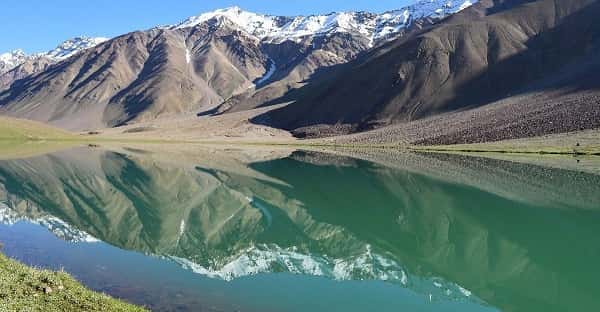
There is a moment — documented by every traveller who has made the difficult journey to reach it — when the trail crests a final ridge and Chandratal Lake appears below in its full, impossible, heart-stopping glory. A crescent of water so intensely blue it appears painted against the brown and ochre of the high Himalayan plateau. Surrounded by scree mountains on one side and glacial cirques on the other. Sitting at 4,270 to 4,300 metres above sea level — over 14,000 feet — in the barren, sky-touching landscape of Spiti Valley in Himachal Pradesh. The name says it all — Chandratal means “Moon Lake” in Hindi, named both for its perfect crescent shape and for the quality of light that plays on its surface at different hours, shifting from deep aquamarine to emerald green to electric blue as the sun moves across the high-altitude sky. Declared a protected Ramsar Wetland Site, Chandratal is not merely one of India’s most beautiful lakes — it is a UNESCO and internationally recognised ecological sanctuary of extraordinary importance. Reaching it is genuinely difficult. But that difficulty is entirely part of the experience. Here is everything you need to know.
Quick Overview — Chandratal Lake Spiti Valley
| Detail | Information |
| Location | Chandra Valley, Lahaul and Spiti District, Himachal Pradesh |
| Altitude | 4,270 to 4,300 metres (14,100 feet) above sea level |
| Type | Natural High-Altitude Crescent Lake — Ramsar Wetland Site |
| Nearest Village/Base | Batal (14 km from lake) |
| Distance from Manali | ~250 km by road (~10-12 hours) |
| Distance from Kaza (Spiti) | ~97 km by road |
| Distance from Kunzum Pass | ~6 km |
| Timings | Open mid-June to mid-October (snow-bound rest of year) |
| Entry Fee | ₹150 per person (Indians) / ₹500 per person (Foreign Nationals) |
| Permit Required | Free e-permit at eaagman.hp.gov.in |
| Camping at Lake | Banned — Camp 2-3 km away at designated sites |
| Camping Cost | ₹1,200 to ₹2,500 per night at designated sites |
| Best Time to Visit | Mid-June to mid-October |
Location of Chandratal Lake
Chandratal Lake is situated in the Chandra Valley of Lahaul and Spiti district, Himachal Pradesh — perched at 14,100 feet on the Samudra Tapu plateau between the Rohtang Pass and Kunzum Pass.
Chandratal Lake is located in the Chandra Valley within Lahaul and Spiti district, Himachal Pradesh, positioned on the Samudra Tapu plateau at an elevation of 4,270 to 4,300 metres above sea level. The lake sits approximately 6 km from the Kunzum Pass — the dramatic 4,551-metre mountain pass that connects Lahaul Valley with Spiti Valley — and approximately 27 km from the main Spiti Valley settlements. It is approximately 97 km from Kaza, the administrative headquarters of Spiti, and approximately 250 km from Manali by road.
The lake measures approximately 2.5 km in circumference and its crescent shape is most clearly visible from the surrounding ridgelines — a shape so distinctly lunar that travellers who first see it from above frequently describe the experience as genuinely otherworldly. The water colour changes multiple times throughout the day — shifting from deep sapphire blue in morning light to turquoise and aquamarine at midday and deep teal at dusk — a visual behaviour caused by the lake’s extreme altitude, the angle of the sun, and the extraordinary clarity of the water. The surrounding landscape is characterised by barren scree slopes, glacial moraines, and the occasional flash of the Chandra River visible in the valley below.
Directions to Chandratal Lake
Chandratal Lake is reached via one of two primary routes — both require crossing major Himalayan passes and are only accessible during the summer season between mid-June and mid-October.
Route 1 — Via Manali and Rohtang Pass: Delhi to Manali (approximately 550 km by road or overnight bus, or flight to Bhuntar Airport near Kullu), then Manali to Chandratal via Rohtang Pass, Gramphoo, Batal, and finally the 14 km track to the lake. Total road distance from Manali approximately 250 km. Journey time approximately 10-12 hours. The road is rough, particularly the final 14 km dirt track from the Manali-Kaza Highway junction near Batal — this section requires a high-clearance 4WD vehicle. The Rohtang Pass typically opens in mid-May to early June and the Batal road to Chandratal opens approximately mid-June subject to BRO snow clearance.
Route 2 — Via Shimla and Kinnaur: Shimla to Narkanda, Rampur, Karcham, Nako, Tabo, Kaza, and then to Batal and Chandratal via the Spiti Valley road. This route is longer but offers the full immersive Spiti Valley experience. HRTC buses serve the Shimla-Kaza corridor and some operators run connections toward Batal.
Trekking Route — The Chandratal Trek from Batal base camp is approximately 14 km one-way — a moderate-to-challenging high-altitude trek that takes 4-5 hours each way through dramatic glacial terrain. Acclimatisation at Batal for at least a day is strongly recommended before attempting the trek.
An e-permit from eaagman.hp.gov.in is mandatory for all visitors — free of charge and available online. This must be obtained before travel and presented at the Batal checkpost.
Timings and Important Rules
Chandratal Lake is accessible only during the Himalayan summer season — visiting outside this window is impossible due to road closure under heavy snowfall.
Chandratal Lake is open for visitors from approximately mid-June to mid-October each year. In 2026, the road via Batal is expected to open around mid-June depending on BRO snow clearance schedules. The lake can be visited at any hour during daylight — most trekkers begin their walk from Batal at dawn to arrive at the lake in morning light, which produces the most spectacular photography conditions. The lake area is accessible from approximately 6:00 AM to 6:00 PM for day visitors. Camping directly at the lake is strictly banned under environmental protection regulations — visitors must camp at designated sites 2-3 km away from the lake, available at ₹1,200 to ₹2,500 per night. Entry fee is ₹150 per Indian national and ₹500 per foreign national. No ATMs exist anywhere near Chandratal — carrying adequate cash from Manali or Kaza is essential.
Activities at Chandratal Lake
Chandratal Lake’s protected status and extreme altitude define its activity possibilities — the experience is about immersion in raw Himalayan wilderness rather than organised recreation.
Trekking from Batal to the lake is the primary activity — a 14 km trail through scree terrain and glacial moraines that rewards the effort with one of India’s most genuinely stunning natural vistas. Photography at Chandratal is among the finest landscape photography experiences in the entire Himalayan range — the lake’s colour-changing water, the surrounding peaks, and the extraordinary night sky (the Milky Way is brilliantly visible at this altitude) create conditions that professional photographers specifically plan expeditions around. Stargazing at Chandratal is world-class — the high altitude, minimal light pollution, and thin atmosphere create star visibility that is genuinely different from anywhere at lower elevations. Circumambulation of the lake — a 2.5 km walk around the lake’s perimeter on a well-defined trail — is deeply spiritual and visually immersive.
Nearby Places
Chandratal’s position between Manali and Spiti places it within reach of some of India’s most dramatic high-altitude landscapes and ancient Buddhist cultural sites.
Kunzum Pass (4,551 m) — The dramatic mountain pass just 6 km from Chandratal, featuring the Kunzum Mata Temple — traditionally circumambulated by all vehicles entering Spiti Valley for safe passage blessings. Batal — The tiny settlement 14 km from the lake that serves as the primary base camp for Chandratal visitors — basic dhabas and camping facilities available. Kaza — The administrative capital of Spiti Valley, approximately 97 km from Chandratal — home to the famous Key Monastery (Ki Gompa), one of the largest Tibetan Buddhist monasteries in India. Suraj Tal — Another spectacular high-altitude lake near Baralacha La, approximately 75 km from Chandratal. Rohtang Pass — The legendary 3,978 m pass connecting Manali to the Lahaul-Spiti Valley, offering dramatic snow views even in summer. Pin Valley National Park — Home to snow leopards, Siberian ibex, and Himalayan wolves — approximately 100 km from Chandratal toward southern Spiti.
FAQs — Chandratal Lake Spiti Valley
Q1. What is the altitude of Chandratal Lake?
A: Chandratal Lake is situated at an altitude of 4,270 to 4,300 metres (14,100 feet) above sea level — one of India’s highest accessible lakes.
Q2. When does Chandratal Lake open in 2026?
A: The road via Batal is expected to open around mid-June 2026 depending on BRO snow clearance. The lake remains snow-bound and inaccessible from November to mid-June.
Q3. Is camping allowed at Chandratal Lake?
A: Camping directly at the lake is strictly banned under environmental protection rules. Designated campsites are available 2-3 km from the lake at ₹1,200 to ₹2,500 per night.
Q4. Is a permit required to visit Chandratal Lake?
A: Yes — a free e-permit is mandatory for all visitors, obtainable through the Himachal Pradesh government portal at eaagman.hp.gov.in. Foreign nationals must also carry their Inner Line Permit (ILP) for the Spiti Valley region.
Q5. What is the entry fee for Chandratal Lake?
A: Entry fee is ₹150 per person for Indian nationals and ₹500 per person for foreign nationals. The fee is collected at the Batal checkpost before the trek begins.